
The F-14B is not equipped with a GPS, neither is the F-14A. Nevertheless, both versions flew for a prolonged period, even after the introduction of new technologies and standards such as digital avionics, GPS, LINK16.
The crews took advantage of the GPS technology on older versions of the Tomcat by means of portable GPS. According to the Osprey “F-14 Tomcat Units of Operation Enduring Freedom” (page 10), the hand-held Garmin Pilot III GPS was one of the devices used by the crews.
DCS has his own stand-alone, cross-module GPS: the Garmin NS 430. Initially released for the Mi-8 and the L-39 (the only two modules featuring a 3D in-cockpit representation of the Garmin NS 430), it is now available for almost any module as a 2D overlay (it seems to have issues for VR players so verify before buying it).
Since even real crews took advantage of GPS devices, why shouldn’t we?
DCS NS 430 Manual & basic controls
The manual of the NS 430 is available here.
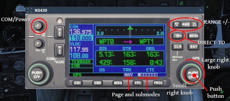
To turn on the GPS, rotate the COM power/volume, located in the top-left corner.
Most of the controls are located to the right of the GPS. The large right knob allows to access groups of functions of the NS 430. The small right knob is used to access the sub-modes of the selected page.
The following is a quick overview of the basic and most common functions of the NS 430 combined with the F-14. I don’t use the Flight Planning and Navigation functions of the GPS because I mostly rely on INS and TCN, therefore such functions will be barely mentioned.
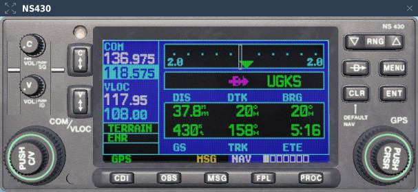
NAV page
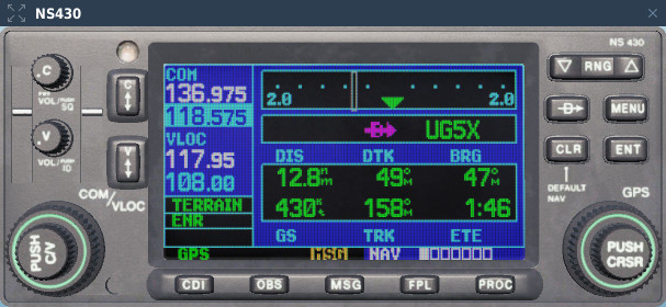
NAV is the first page group and consists of 6 sub-modes. The first and default sub-mode is NAVdef, that displays a number of useful information about navigation. If there is no destination or flightplan set, most of the fields and the graphic display are blank.
A screenshot of this page is visible above. In this case a single waypoint has been created via the mission editor.
The second sub-mode is NAVmap. This mode shows a coloured moving map centered on the aircraft and oriented similarly to the TID in Ground Stab mode. The displayed range can be adjusted by means of the two dedicated buttons on the right of the screen.

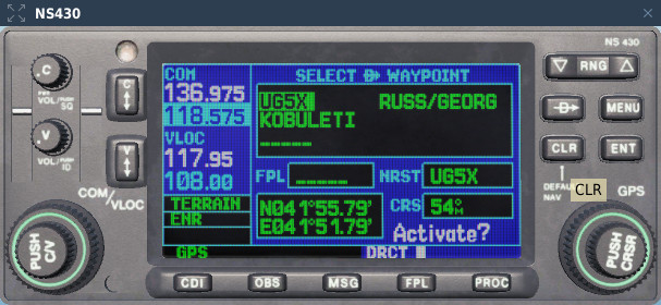
The map can also be panned by means of the right small knob and a position can be assigned as the current destination by pressing DIRECT-TO and ENT twice (details at page 19 and 20 of the manual). This function is very useful if the INS is degraded and the airfield destination doesn’t have a TACAN station. It can also be used as a sort-of ERBL (a function of the ABRIS, aboard the Ka-50).
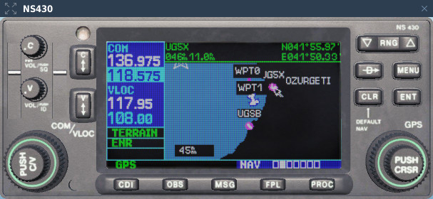
If the mission has a pre-set FP created in the mission editor, it will be present in the NS 430 at the beginning of the mission.
The third sub-mode is NAVterrain. This mode shows the terrain in a coloured scale depending on the elevation. This in one of the most commonly used mode in the F-14 if you haven’t created a FP.
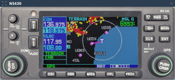
The active Waypoint here displayed has been selected in the example above, by means of NAVmap and DIRECT-TO mode.
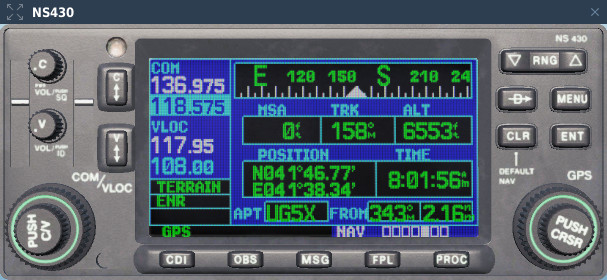
The fifth sub-mode is NAVpos. This modes displays the position of the aircaft along with its altitude, ground speed and other info. Such data are fundamental to perform an unorthodox INS position update.
WPT page
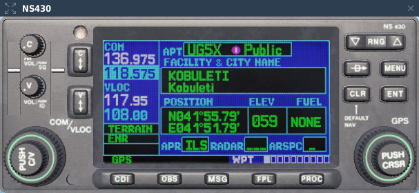
This page and its sub-modes display details about the current waypoint. Usually, unless you are flying a pre-built mission or created a FP yourself, you won’t use this page unless you have selected a destination by means of DIRECT-TO.
The first and second sub-modes of the WPT page are very useful especially if the destination airfield has no TACAN station, as often happens in the northern part of the Caucasus map.
The first sub-mode of the WPT page is WPTero. It provides the coordinates of the Airport, elevation and other information.
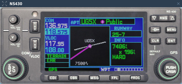
The second sub-mode is WPTrunway. The available runways of the selected airport are displayed.
As I mentioned already, the WPT page and its sub-modes are not as commonly used as the others unless you plan to create a complete FP or using the DIRECT-TO mode.
More details about those are available in the manual.
NRST page
This is the fourth page and provides information about nearest airports, VOR, NDB and so on, within 200 miles from your current location. It can be useful in case of emergency or unexpected situation.
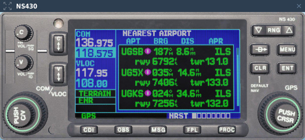
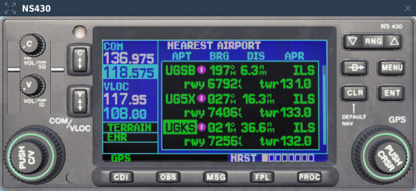
NRSTapt, for example, allows to select an airfield and see its details by pressing the small right knob (this operation activates the cursor) and selecting an airport ICAO code:
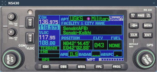
By pressing ENT, information about the airfield are displayed. Press ENT again to return to the previous page:
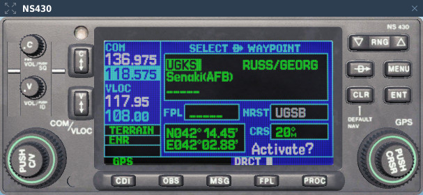
The airport highlighted can be used in conjunction with the DIRECT-TO mode. Select the airport and follow the same steps we followed before:
Other functions
The NS 430 provides information about precision and non-precision approaches and allows the creation of detailed Flight Plans. Such topics are beyond the scope of this article so I won’t cover them. More info are available in the manual.
ToManyFunctions;Didn’tRead?
This is a summary of the functions that I use the most. Depending on your use of the Flight Planning functions, you may use the following functions or others I haven’t covered.
NAV (first page group)
- NAVmap (2nd sub-mode): moving map, can be panned and the destination can be used as destination or to measure distances.
- NAVterrain (3rd sub-mode): moving map, shows the terrain elevation.
- NAVpos (5th sub-mode): displays the position and altitude of the aircraft, time, ground speed and other info.
NRST (fourth page group)
- sub-modes allow to select between nearest airports, NDB, VOR, etc.
NS 430 rotary knobs
When assigned to a joystick button, such as a rotary encoder, the knobs of the NS 430 tend to turn more than one page or sub-mode with a single pressure. This behaviour is similar to the one of the knobs of older modules, such as the KA-50 and its ABRIS.
I found a workaround on ED’s forum, credits to Mr Chic. I suggest you to use it along a mod manager such as OvGME.

During the period in question, maneuverability was enhanced by relaxed static stability, made possible by introduction of the fly-by-wire (FBW) flight control system (FLCS), which in turn was possible due to advances in digital computers and system-integration techniques. Replacement of analog avionics, required to enable FBW operations, became a fundamental requirement as legacy analog computer systems began to be replaced by digital flight control systems in the latter half of the 19.
LikeLike
Not without some problems with the hendheld GPS (http://www.anft.net/f-14/f14-serial-loss.htm)
F-14B VF-143
12.08.1997: The pilot of the F-14B was accidentally ejected from the aircraft during a landing aboard USS John C. Stennis. It’s said that the Rio had an older GPS system they used to clip to the handle on top of their console. He hadn’t stowed it prior to arrestment and during the violent stop from the hook/wire the GPS system got thrown forward from momentum and hit the pilots rocket motor iniator which bypassed the whole ejection system (pilot never touched the ejection handles …) Next thing the pilot went THROUGH the canopy! He was recovered from the water by helicopter. Stennis personnel rescued the RIO from the pilotless aircraft as it sat on the flight deck with engines still running. Aircraft was repaired and is back in service.
LikeLike
Eheh I read about that event. What the crew failed to understand is that the GPS is actually a backup emergency ejection system 😀
LikeLike