
The analog INS of the F-14 tends to drift surprisingly fast, especially when pulling some Gs. There are a number of ways to re-align the INS and to update the aircraft position, one of which is by means of the TACAN.
This article goes into the details of the Visual update.
The procedure, per se, is quite straightforward. From the manual:
To perform a visual fix, fly over a prestored waypoint and press the VIS FIX button. Estimate your timing, because the aircraft nose and fuselage can obscure the fix point during overflight. It is also difficult to estimate when directly overhead a waypoint if the aircraft altitude is greater than 10.000 feet. The delta for the visual fix is displayed on the TID. Enter the delta by pressing FIX ENABLE.
- Hook desired update point (WAY PT, HB, IP, etc.).
- Select NAV category on CAP.
- Overfly the selected prestored point and when over the point, depress the VIS FIX button on the cap.
- If the delta is not satisfactory, press VIS FIX again to clear the delta and repeat from step 1.
- If a satisfactory delta is displayed, depress the FIX ENABLE button; this causes the delta correction of own-aircraft position to be inserted into the computer.
This method is much simpler than the TACAN Fix: there are no considerations about the Magnetic Variation or the distance from the TACAN station. On the other hand, the outcome heavily depends on how precisely the crew can fly over a defined point.
Choosing the waypoint
This issue is similar to the main problem of the CPTR IP delivery: how to get an easily identifiable point, both visually and on the F10 map (or other source of precise latlong coordinates)?
A simple option and a good introductory exercise is the visual fix over an airfield. Although sometimes redundant due to the presence of TACAN stations, it’s a very handy exercise to get the crew up to speed with the procedure. I usually fly over the runway perpendicularly to it, so it’s fairly easy when the F-14 is over the runway by using the wings as reference (both mag and true direction of the runway are available from any airdrom chart). The same concept can be applied to any fairly straight main road.
When using other ground features or peculiar buildings as waypoints, the problem is understanding when the aircraft is exactly above such point. A good practice is flying over the waypoint, look for a reference point at 090°/270° (or other easily notable angle) and do a dry-run to visually capture the position of the reference. Then do another pass and when the reference is in the correct position, update the aircraft position.
If the reference waypoint is hard to spot (better if it’s not!), try using the TCS. Although fairly limited, it can be very useful to adjust the heading.
This is a simple example of Visual Fix in the southern part of the map, too far from any TACAN station. I looked for something easily identifiable and I spotted this peculiar shape:
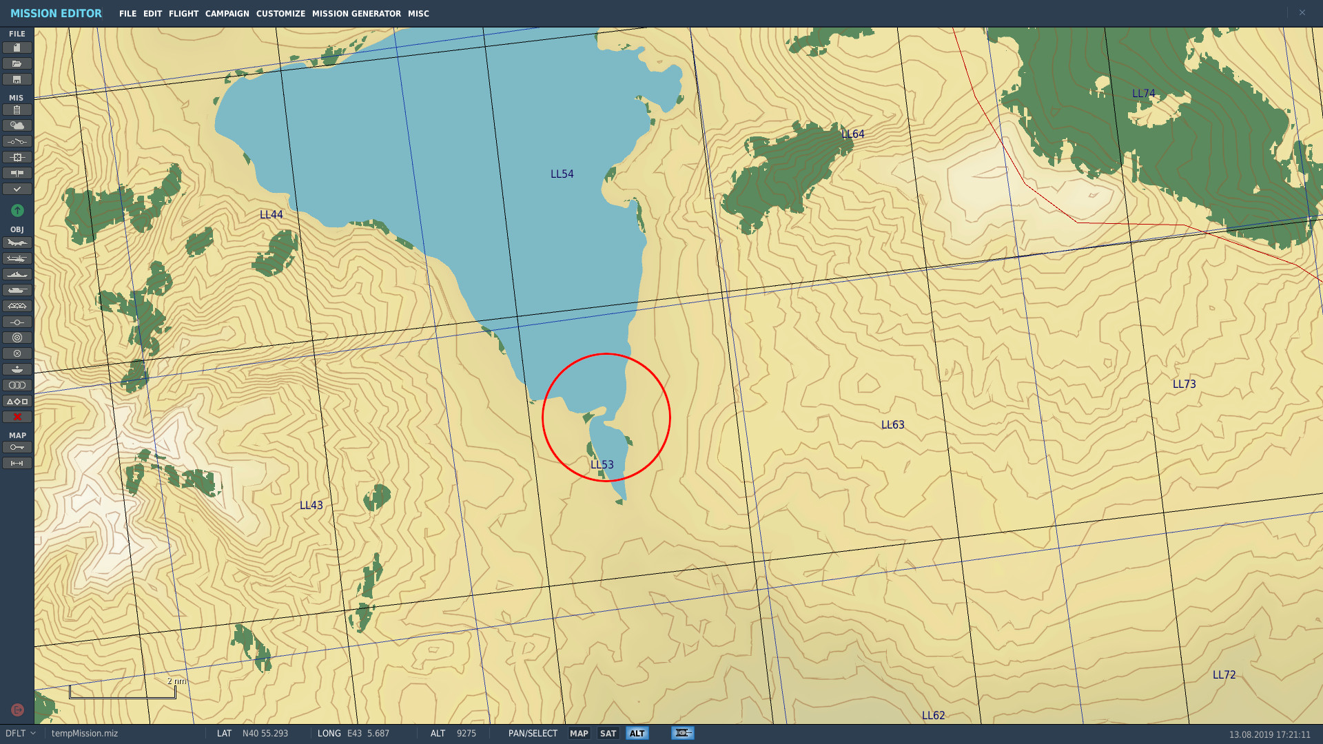
I created a waypoint in the of the eastern peninsula and my goal is using the northern peninsula as reference point. I created the waypoint approximately 180° from my reference point, therefore by flying east-west, I should have the reference at 3′.
This is a screenshot of the moment I updated the aircraft position. In order to have the same point of view during both the dry-run and the alignment run, I kept the air intake fairly aligned with the IFF panel and used the area between the Flares Salvo and the AN/ALE-39 as “marker”.

This is the view from the F10 map. I missed my waypoint by a couple millimeters (in the picture – the waypoint was a little bit more to the west) but I was quite happy anyway. I also measured the distance between the aircraft and the end of the peninsula to provide a quick visual scale of the map. As you can see, that value is only 0.05nm so the Visual Update in this case has been quite successful.

Keep in mind that the F-14B INS is not a “JDAM-precise” tool, so don’t try to be precise down to a millilitre because it’s pointless. Nevertheless, even if this method is not very accurate, it can fairly quickly solve the problem of a badly drifted INS.
A couple of notes
- The waypoint should be created as usual and the necessary data can be found in the F10 map;
- When dealing with heading & bearing, remember to compensate for the magnetic variation;
- The Pilot can increase the chances of success by flying fairly low (in the screenshot above I was approximately 1500ft AGL) and slow, in order to give the RIO a little bit more to fix the reference;
- The Pilot should also be an active part of the process, suggesting visual references and locations for the waypoint. After all, he has to fly there.
Unfortunately the F-14B doesn’t come with an onboard GPS.. usually. The next article about the INS will cover a couple of “unorthodox” ways of updating the aircraft position, on top of other INS Fix methods.